

An Bhinn Dubh [Bencollaghduff]
Good walks are even better shared.
L7952 : Summit cairn on Bencollaghduff with view towards Benbreen & Bengower
Colin Park Photo source
Overview
An Bhinn Dubh [Bencollaghduff]
Introduction
An Bhinn Dubh, known to many as Bencollaghduff, is a hike that truly packs a punch in the scenic stakes. Nestled within the beautiful Maamturks range in Connemara, it stands proud at 703 meters. From spectacular views to thrilling ascents, there’s plenty here to capture the hearts (and feet) of outdoor enthusiasts.
Geology
One interesting aspect is its foundation of Lewisian Gneiss — a true relic of the Earth’s history! These ancient rocks not only form the body of An Bhinn Dubh but carry fascinating stories of geological processes that date back billions of years. So, when climbing, remember you’re literally walking on history!
Trails and Routes
The main route, the Bencollaghduff Loop, is the way to go for most hikers looking for a hearty challenge without media frenzy. Spanning approximately 10.5 km, it offers a delightful journey through rugged moorland and moderate inclines, making it manageable for those with a moderate level of fitness. Aim to take about 4 hours; give or take, depending on how often you stop for that all-important snack.
Summit Features
Upon reaching the summit, you'll find a rustic cairn, which is more than just a pile of rocks — it’s a landmark that celebrates the spirit of those who have come before you. Perfect for nestled snacks or a group photo with the friends that got you here (thanks, guys!).
Terrain
The terrain is primarily grassy, with occasional rocky outcrops and some boggy patches. Pro tip: Bring sturdy shoes — you'll thank yourself later when you avoid a soggy sock situation!
Views
On a clear day, prepare to be wowed by the views across Loughs Inagh and Mask, as well as the majestic Twelve Bens in the distance. In the late spring and early autumn, these vistas are at their best, showcasing Connemara at its finest.
Hazards
However, don’t get too caught up in the views — always keep an eye on changing weather conditions, which can swing from sunny to misty quicker than you can say 'scone'. Also, watch out for those tricky bogs — they have a tendency to surprise!
Access
Getting there is straightforward. Park at L795298 — there’s ample space for several cars, so don’t worry about finding a place to squeeze in. Public transport is a bit of a challenge, so driving is preferred, especially if you're carrying a picnic basket!
Nearby town: The charming village of Leenane is a mere 8 km away and fairy-tale like in its composition, perfect for a post-hike drink or sustenance.
Facilities
After conquering the mountain, you’ll find delightful cafes and restrooms in Leenane to replenish those lost calories (and calories lost are the best kind!).
History
As for its name, An Bhinn Dubh translates to 'the black peak' — an apt descriptor for its formidable and wild character. Locals have long revered this mountain, marking it as a significant landmark in the Irish landscape.
So there you have it — An Bhinn Dubh, a mountain that promises adventure, beauty, and just a touch of local lore. Happy hiking!
Explore routes near An Bhinn Dubh [Bencollaghduff]
Walks starting near this hill. Open a route to check its map, distance and full itinerary.
Route planning notes
These notes describe possible approaches. Check a route's map and access information when planning your walk.
Bencollaghduff Loop
A stunning loop starting from the parking area at L795298, taking you through beautiful moorland and ascending the gentle slopes of An Bhinn Dubh.
Make a day of it, together
Find someone to share the walk with, or organise a day out along a route you like.
Photo Gallery
View all Photo could not load
L7952 : Summit cairn on Bencollaghduff with view towards Benbreen & Bengower
Colin Park
Hill facts and local notes
Classifications
Elevation
697m
2,287 ft
Prominence
203m
Coordinates
53.5125, -9.8142
L797529
OS Map
37
At the Summit
The summit features a prominent cairn, which provides the perfect spot for a well-deserved snack break and the epitome of a 'satisfying' selfie.
Terrain & Geology
Primarily composed of Lewisian Gneiss, which forms some of the oldest rocks in Europe. Its weathered surface and unique contours make it a geological wonder.
Views & Scenery
Breathtaking views of Loughs Inagh and Mask, as well as a sweeping panorama of the Twelve Bens range. On a clear day, you might even wave to a sheep or two on the distant hills!
History & Heritage
Name Origin
The name 'An Bhinn Dubh' translates to 'the black peak,' possibly referencing the dark, rugged terrain that gives this mountain its character.
Historical Significance
An Bhinn Dubh holds cultural significance for local communities, who have historically regarded this and surrounding peaks as important landmarks.
Getting There & Facilities
Parking
Parking available at L795298, which can accommodate several cars. The road is easily accessible from the main routes.
Public Transport
Limited bus services run from nearby towns; the most reliable way is to drive.
Nearby Facilities
Basic facilities such as cafes and toilets are available in Leenane. For a quick drink, try the local pubs!
Safety Information
Known Hazards
- Variable weather conditions that may change rapidly. Keep an eye out for tricky bogs, particularly in wet weather.
General Safety Tips
- Check weather conditions before setting out
- Carry appropriate clothing and equipment
- Let someone know your planned route
- Take a map, compass, and GPS device
- Carry emergency supplies: food, water, first aid kit, torch
Hills
Some common questions about the hills answered
Are there group walks up An Bhinn Dubh [Bencollaghduff]?
Many walkers use Walkmates to join or organise walks with others. You can check for group walks around An Bhinn Dubh [Bencollaghduff] through the maps
Are there other walkers around An Bhinn Dubh [Bencollaghduff]?
Activity varies by location and time, but Walkmates lets you see whether others have shared walks or shown interest in this area. Find other people through the walking friends search walking friends for An Bhinn Dubh [Bencollaghduff] search or of course create your own walk for An Bhinn Dubh [Bencollaghduff]
Can I organise a walk to An Bhinn Dubh [Bencollaghduff]?
Yes. If there aren’t any walks listed already, you can create a walk and make it available for others to join.
If you're signed up to Walkmates, you can create a walk to An Bhinn Dubh [Bencollaghduff].
How do I find a walk up this hill?
There are often multiple ways to walk this hill, depending on experience and route preference. Walkmates helps you explore walks and routes that others have shared.
Can I suggest a new route up An Bhinn Dubh [Bencollaghduff]?
Yes. You can suggest or create routes to share with others. Walkmates focuses on the social side of walking, so routes are used to help people organise walks and explore areas together, rather than as detailed navigation tools or route libraries.
Other uses really appreciate knowledgeable walkers sharing their routes. Share your favourite route to An Bhinn Dubh [Bencollaghduff] here
The is an error or something incorrect about this hill. How do I let you know?
We always strive to keep the information on Walkmates as accurate as possible. If you find an error, please let us know through the contact form and we'll aim to correct it as quickly as possible
Community Discussion
Comments
Location
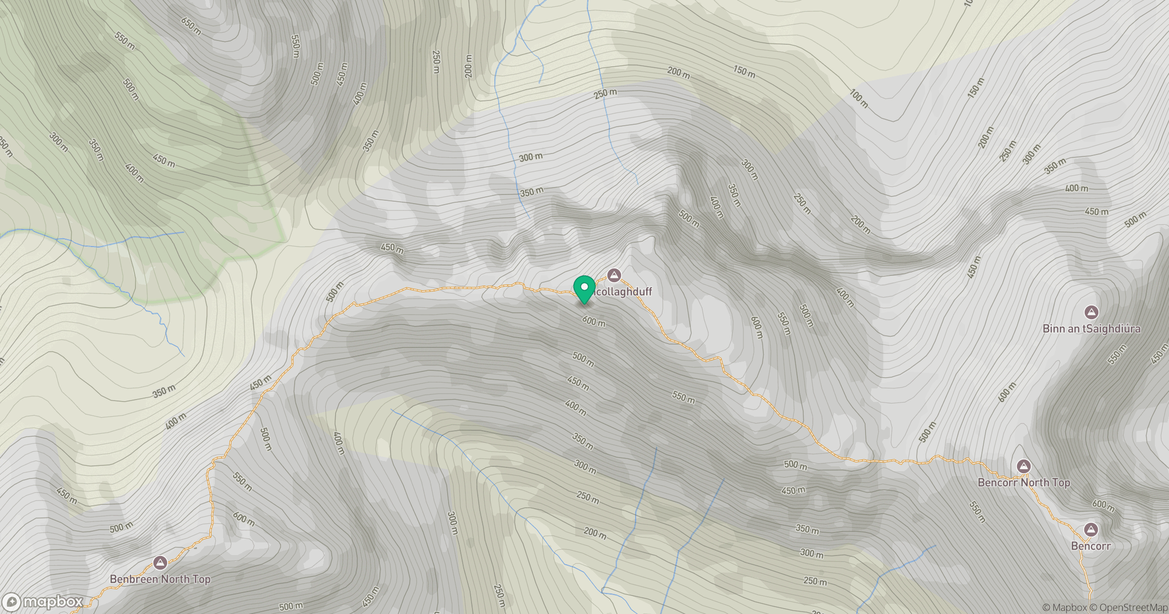
Grid reference: L797529
View on OpenStreetMapOpens a map in a new tab, centred on the hill.
No comments yet. Be the first.